Tuesday, August 31, 2010

CANBERRA FOREIGN EMBASSIES

A 1962 British Pathe newsreel showing Canberra's diplomatic embassy/residences. Nice footage of newly established embassies including Indonesia, South Africa and the United States. The backdrop footage shows an open and relatively undeveloped 1960's Canberra.


Australian commentary. VS. Large modern buildings in their own grounds, which are the embassies of America, France, Canada, etc. in Australia. GV. Flock of sheep on hillside, with Canberra in background. 


FOREIGN EMBASSIES AROUND CANBERRA


(opens in a new window)

Share - 

Monday, August 30, 2010

NAMING OF CANBERRA

Another newspaper clipping discussing the naming of Canberra. This article from The Sydney Morning Herald - 14 November 1942 by Frederick Slater alludes to the name Canberra - Canburry - Canberry etc. as being of English origin and not Aboriginal as is widely accepted today...


National Library of Australia (here)

Share -

Sunday, August 29, 2010

NAMADGI ROCK ART VIDEO

A Video from Canberra naturalist, wildlife conservationist and television presenter Carly Wilson showing the Rock art at Namadgi National Park in the Australian Capital Territory. She narrates an explanation of the animals portrayed in the art and their significance to several local Aboriginal peoples.

Yankee Hat Rock Art Image Wikipedia (here)


"A quick visit to the rock painting site at Namadgi National Park near Canberra. These paintings are said to be at least 800 years old. Aboriginal countries in Australia would meet at this site to feast on Bogong moths and have a corroboree (a ceremonial meeting). A truce would be in place during the corroboree".

Carly's Website (here)
YouTube Channel (here)


Share -

DUNTROON GOLDFIELD


During the Australian gold-rushes of the 1850-60s goldfields sprung up at Appletree Flats, Adelong, Lower Adelong and Araluen. Interestingly Duntroon, today's Royal Military College, is described as a gold field in 1868 and that a promising shaft had been sunk to a depth of 60 feet (18 M). This clipping from the Sydney Morning Herald - 20 October 1868 reports on the "Duntroon goldfield"...


National Library of Australia (here)
Image Wikipedia (here)

MAP

View Larger Map

Share -

Saturday, August 28, 2010

AUSTRALIAN ALPS

The recent snows on the Brindabella Mountains has prompted the following two videos from the New South Wales National Parks Service showing Canberra's Brindabella's as they stretch into the Snowy Mountains. the following commentary was attached...


"Stretching from Canberra through the Brindabella Range to the Snowy Mountains of New South Wales and along the Great Divide through eastern Victoria, Australia's alpine and subalpine environments are unique and special. As a well-watered, snow-clad and mountainous area in a mostly dry and flat continent, the Australian Alps with 1.6 million hectares of protected areas are of great significance". 

"The parks contain plants and animals found nowhere else, a rich and diverse Aboriginal and European cultural heritage, magnificent outdoor recreation and tourism opportunities and the headwaters of some of Australia's most important rivers. The Australian Alps National Parks program involves the Governments of New South Wales, Victoria and the Australian Capital Territory in a cross border cooperative management program aimed at managing the alps as a single biogeographic unit".

AUSTRALIAN ALPS I


AUSTRALIAN ALPS II


Share -

Friday, August 27, 2010

CANBERRA HOVERCRAFT RACE

A British Pathe newsreel film from 1964 depicting the "worlds first hovercraft race" on the waters of the newly filled Lake Burley Griffin in the Australian Capital Territory.

Allan Hawkins - the winner

Title reads 'World's First Hovercraft Race'.

MS. Governor General of Australia Lord De L'Isle has arrived to Canberra to watch the home made hovercraft race. Various shots at Lake Burley Griffin where competitors turn up with their crafts. The hovercraft have all been made privately by the entrants. After a short preparation they take to the water, some have difficulty. The race is won by Alan Hawkins in a beetle shaped craft.

Date found in the old record - 19/03/1964.

HOME MADE HOVERCRAFTS RACE

(opens in a new window)

Share - 

Thursday, August 26, 2010

US LEGATION TIME CAPSULE


67 years ago a copper box containing documents was sealed in a cornerstone of the American Embassy in Canberra. Amongst the documents enclosed is a colour photograph of US President Franklin D. Roosevelt (bio), two copies of the Canberra Times and a bridal bit (horse) used by Robert Campbell of Duntroon, first settler on the Limestone Plains of present day Canberra...

The Canberra Times - 5 May 1943


National Library of Australia (here)

The United States Embassy in Canberra

View Larger Map

Share -

Wednesday, August 25, 2010

THE SEEKERS IN CANBERRA


44 years ago The Seekers (info), a popular music group in the 1960's filmed what today would be called a video clip with their famous song "A world of our own" in the streets of Canberra. They visit Old Parliament House, several embassies, (even driving past the front door of the American Embassy) and cruise the streets of 1966 Canberra in a way that would probably see them arrested today. I just loved it...


Share -

Tuesday, August 24, 2010

TRAVELLING BY MAIL-COACH


This newspaper clipping from The Colonist - 11 July 1838 describes a strenuous journey at the hands of mail coach operators whilst travelling from Sydney to the Limestone Plains. After detailing the events, equipment, horses and other travelers the writer desires to know if any compensation could be gained from the proprietors for the appalling journey...


National Library of Australia (here)

Share -

Monday, August 23, 2010

DUKE OPENS MINT

Image Wikipedia (here)

A video of a British Pathe newsreel dated March 1965 showing the opening of the Royal Australian Mint in Canberra by the Duke of Edinburgh (bio) as Australia moved to decimal currency.

The title reads: "DUKE OPENS MINT". Canberra, Australia. L/S the new mint. C/U crest above door. M/S Duke of Edinburgh (Prince Philip) arriving for official opening. C/U pan ditto.


Interior; the Duke walks into the mint. L/S ditto. L/S Duke starting coin press. Panning shot one of the presses. C/U new decimal coins going down chute. C/U presses coins coming through chute. M/S Duke inspecting coins. Pan L/S ditto. C/U coins coming through another chute.


M/S Duke walking in the coin museum. C/U some of the coins. M/S Duke inspecting coins. C/U an 1809 "Holey Dollar". C/U ingot currency from the 19th Century. C/U two 1855 sovereigns. C/U box of new decimals coins which were presented to the Duke. C/U ditto.

DUKE OPENS MINT

(opens in a new window)

The Royal Australian Mint website is (here)

Share -

Sunday, August 22, 2010

THE ZIG ZAG BORDER

Yesterday I attended the Show Us Your Limits "walk and talk" to see the northern ACT boundary survey markers as they zig-zag across the higher ground of the Australian Capital Territory's border. The walk was led by Pastor John Evans of the Canberra Bushwalking Club and covered a six kilometer round trip through the northern section of the Mulligan's Flat Nature Reserve.


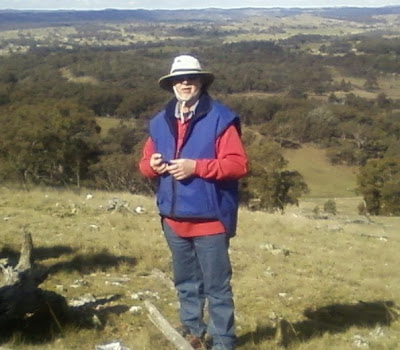
National Trust of Australia Heritage Officer Dr. Peter Dowling and Museum of Australia historian Matthew Higgins related stories of the borders creation at the beginning of the 20th century as the new Federal Capital Territory was carved out of the watershed of the newly formed territory. The walk began at the northern entrance to the reserve at the junction of Mulligan's flat Road and the old Gunderoo Road where we began our accent towards Oak Hill.

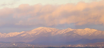
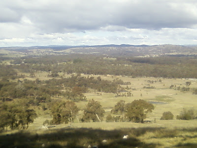
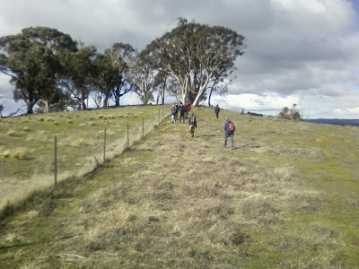
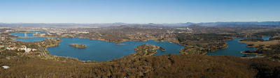
A view from Oak Hill towards Mulligan's Flat

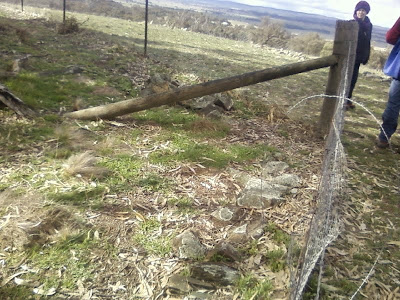
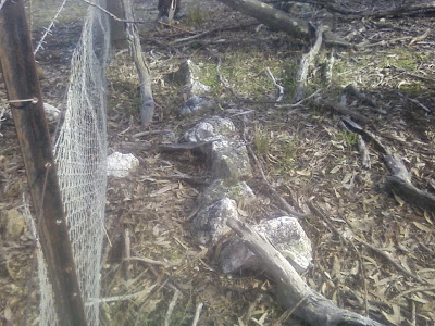
The border literally zigzags across the rounded hill tops changing direction constantly to capture the water catchment for the Federal Territory. At every change of direction a survey post was installed with a line of rocks to indicate the change in direction (Lock Spit). These rock lines left no doubt as to the line of the border and subsequent surveys to "check" the borderline have found the original survey to be very accurate. It is interesting to note that stock fencing along the border has been built not on the survey lines but a few feet on the ACT side.

 
Lock Spit at a "turning point".

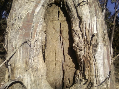
Marker trees were also cut next to the border "turns" that further indicated the borders progression. The trees we saw were unfortunately overgrown after a hundred years but a good example of a survey blaze tree is located near the carpark at the beginning of the walk. (pictured below).


Surveyor Percy Sheaffe and his team under the direction of Charles Scrivener (1855 -1923)(bio) surveyed this portion of the border in May 1911. The border zigzags it's way along the crests and slopes picking up the edge of the watershed. Rainfall reaching the ground on the ACT side will flow into the Ginninderra Creek catchment then into the Molonglo River whilst rain falling on the NSW side of the fence will flow towards the Yass River.

National Trust of Australia Heritage Officer - Dr. Peter Dowling

At every turn of the border the Lock Spits are visible however after a century many have been disturbed by stock and fencing practices by land owners. Also unfortunately many of the timber survey posts have been lost over time.

Lock Spit

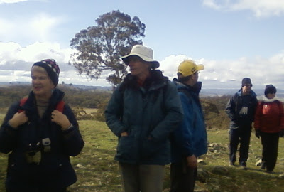
Museum of Australia Historian - Matthew Higgins (centre)

A good example of the watershed line of the border

The day was informative and a little challenging and I would like to thank John Evans, Matthew Higgins and Peter Dowling for imparting their experience and knowledge on a cold and windy day.
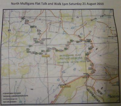
MAP

View Larger Map

Share -

Saturday, August 21, 2010

THE GINNINGINNINDERRY MAILRUN

A short newspaper article from 1835 calling for the residents of the "extreme places" to pay for someone to deliver their mail. End of the line Ginninginninderry...


The Sydney Monitor - 21 November 1835


National Library of Australia (here)

Share -

Friday, August 20, 2010

CANBERRA'S BORDERLINE

The video below is from the filmmaker Richard Snashall who interviews National Museum of Australia historian Matthew Higgins. Matthew has a tremendous knowledge of the ACT border, having walked almost the entire length of the Australian Capital Territory's border and having researched and written extensively on the subject.

Charles Scrivener (1855-1923)(bio)

Before the video this newspaper clipping from The Canberra Times dated 4 June 1954 describes the conditions under which the first survey teams mapping the newly formed Federal Capital Territory had to operate in the very early 1900's. The article quotes Mr. Arthur Percival (1879-1964)(bio) former Commonwealth Surveyor-General whilst addressing the Canberra and District Historical Society.


Video - Borderline of Australia's new capital


Share -

Thursday, August 19, 2010

CANBERRA BUSHRANGERS IV


"Billy the Rammer" a convict in the employ of G.T Palmer from the Ginninderra region of the Limestone Plains turns to bushranging in the early years of settlement in 1835. After being arrested in the Limestone Plains region he is transported to the Goulburn Goal where he promptly escapes and continues his rampage with others south of today's Canberra on the Monaro Plains...

The Sydney Herald - 30 April 1835


National Library of Australia (here)

Share - 

Wednesday, August 18, 2010

FEDERAL CAPITAL - GIGANTIC PARK


While a Federal Capital of Australia was still a glint in the new nations eye debate continued as to what type of city would be created. During a debate about a paper written by Mr. Knibbs on the theory of city design suggestions came forth such as the future city's design should be a "gigantic park" with buildings and streets inserted as "details" when required. Mr. J.H. Maiden is quite specific with his vision for a new Federal Capital for Australia...

The Sydney Morning Herald - 4 October 1901


National Library of Australia (here)
Top image National Archives (here)
Cntr image National Archives (here)

Share -

Tuesday, August 17, 2010

CANBERRA GETS NEW LAKE

Below is a video of an old newsreel from British Pathe reporting the opening of Canberra's Lake Burley Griffin. Footage in the newsreel includes Prime Minister Sir Robert Menzies (1894-1978)(bio) officiating at the opening and some nice images of the Molonglo River. The film reports the lakes dimensions and shows the lakes recreational uses, lake surrounds and buildings after filling in 1964.


CANBERRA GETS NEW LAKE

Title reads: "Aquatic Display. PM Opens Canberra's Lake". Australian voiceovered newsreel material. "BGV Various of large Lake Burley Griffin which is a new main feature in Canberra. VS Fast flowing small river which supplies the lake. VS Australian Prime Minister Sir Robert Menzies attends opening ceremony of lake and a special plaque. VS Yachts and dinghies out on the lake. VS At night fireworks." (Comb.F.G.) Old record suggests that material dates from around 25/10/1964.

(opens in new window)

MAP

View Larger Map

Share -

History lost through lack of funding

  The following ABC article laments the possible loss of many historical audio visual records that are waiting for digitising into modern fo...