Friday, December 31, 2010

CANBERRA'S NEW YEAR


This clipping comes from the first new year's eve of the new Canberra. Described as a 'city of dreams' I find the reference to the couple married in a 'corrugated iron cathedral' delightful and as the author hoped would happen help with the events recollection 82 years on. I would just like to thank all the readers of my little blog a happy new year and wish you all a happy and prosperous 2011, the start of the 21st centuries 2nd decade... Love it.

The Mercury - 3 January 1928

National Library of Australia

Share -

Wednesday, December 29, 2010

WESTERMAN'S HOMESTEAD VIDEO


John Evans latest adventure and 360 degree views from the 1916 Westerman's Homestead via the Settler's Track in the southern Namadgi National Park in the ACT. There is some additional information on the history of, and a good series of photos showing, the homestead here.

"A gentle ramble around The Settlers Track in the southern ACT, with extensions to the border to see the 112M marker and the NSW portion reference tree."  John's Blog as always provides extras such as additional photos, maps and Picasa slideshows.


Share -

Monday, December 27, 2010

TRACING OF AN HISTORIC CANBERRA MAP


This is apparently a tracing of the first land survey of what was to become the Federal Territory conducted by Surveyor George Dixon (actually I believe Robert Dixon (bio). It is a map of the community in the mid 19th century settlement of the colony of New South Wales, what was later to become Canberra...

Federal Capital Pioneer - 22 April 1926


Go to the National Library of Australia to view larger image

Share -

Saturday, December 25, 2010

TEN DAYS OF CANBERRA CHRISTMAS 1923 - 1932


Merry Christmas! The following article explores a decade of Christmas's from the earliest days of Canberra's development. The commentary is fascinating if you have the time for a good Canberra Christmas read...

The Canberra Times - 13 December 1933


National Library of Australia

Share -

Friday, December 24, 2010

CHRISTMAS NEWS AND NOTES 1917


I was poking around in Trove and found this newspaper clipping from the Canberra area during World War One. The article describes the mundane news, social gatherings and respectable gossip of the area with a few tactfully? placed advertisements sprinkled through. 

What I found striking about the clipping was that while the ordinary happenings of life unfolded in the region Christmas 1917, one soldier was reported as safely home to Queanbeyan, one was reported as wounded in Egypt and three brothers from Sydney were reported as killed within the space of two days on the Western Front...

Queanbeyan Age and Queanbeyan Observer - 21 December 1917


National Library of Australia

Share -

Thursday, December 23, 2010

NO CHRISTMAS WORK IN CANBERRA 1933


Hard times during the great depression of the 1930's. Interesting as it is alluded to that unemployed men were moved on from Canberra by the police with their entitlement of one issue of rations...

Western Argus - 19 December 1933


National Library of Australia

Share -

Monday, December 20, 2010

SHEARING AT CUPPACUMBALONG - 1873 POEM


This poem comes from a time in our history when the wool-clip was by far the Colony of New South Wales biggest single export and employer of labour. The original poem (there is unfortunately no author named) was published in 1873 in the Queanbeyan Age about shearing in the woolshed at Cuppacumbalong near Tharwa. Conditions of employment, relationships with the employer, the effects of the weather and even the rewards at the end of each shed are related in this entertaining Christmas poem...

Queanbeyan Age - 9 January 1873


National Library of Australia


Share -

Saturday, December 18, 2010

SMITHS ROAD BRIDGE - GUDGENBY RIVER


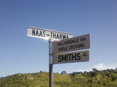
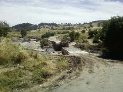
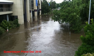
During our recent floods in the ACT the Smith's Road community (website) out past Tharwa suffered a blow when the Smith's Road bridge over the Gudgenby River washed away. This effectively cut the residents off and at one stage necessitated the delivery of supplies and medical needs by helicopter.


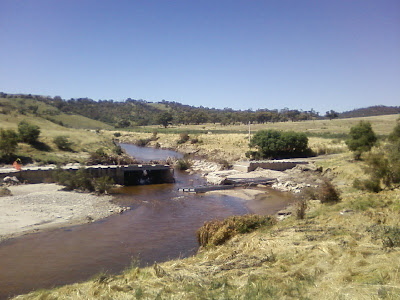
The 7 creeks and 2 rivers that feed the Gudgenby created a powerful rush of water flowing eventually to the Murrumbidgee. The Gudgenby River's only obstacle was the low level concrete causeway on Smith's Road linking the Eastern ACT with West. Low level bridges further down the Murrumbidgee survived as usual with the torrent flowing both over and under the bridge as per the bridge's design.


Why did this bridge wash away now? It has been suggested that the government Willow tree removal program in the ACT may have been a contributing factor. When the Willows were cut down on the river's bank's the cut down trunks and branches were stacked up into piles. These piles were picked up in the fast flowing floodwater and washed down to lodge against the bridge restricting the river's flow and eventually blocking it.


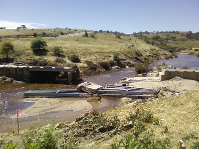
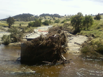
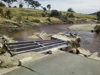
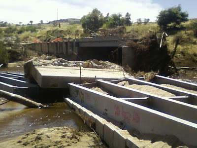
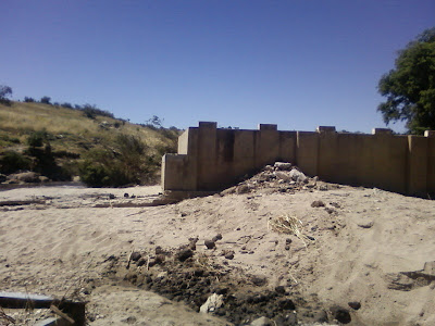
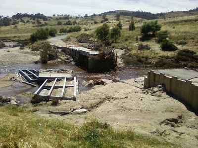
I imagine the forces must have then become intolerable for the integrity of the bridge as evidenced by a large section of concrete and steel top-deck flipping over and settling upside down several metres downstream. The picture of the far side of the bridge shows what the buildup of willow debris must have looked like along the length of the old bridge. The whole scenario seems to me quite plausible.


 With the last decade having been drought I can excuse the ACT government for not foreseeing this possibility as being of any urgency however I might comment that in every other state in Australia the piles of willow would have been burnt when dry. An expensive lesson in noxious weed removal practices perhaps?


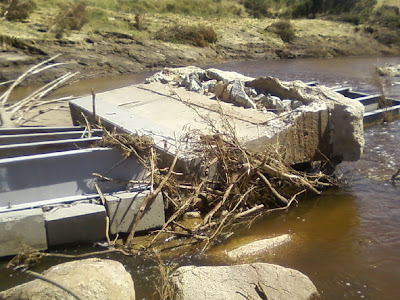
An indication of the river's forces against the bridge is this large concrete 'slab' of what must be an enormous weight upturned in the river itself...


I have a post with pictures of what the bridge used to look like (here)

Share -

Friday, December 17, 2010

THAT URIARRA PUNT


Calls by the "folk" of Uriarra for a punt (info) to carry people and goods across the Murrumbidgee River to the lands beyond were met with the supply of a boat by the government which remained in the vicinity of the Queanbeyan railway station. The boat appears to have been ignored, it was a punt they wanted...

Queanbeyan Age - 11 January 1888

National Library of Australia

MAP

View Larger Map

Share -

Thursday, December 16, 2010

CANBERRA'S CHRISTMAS TOURISTS


It's Christmas and I liked this old newspaper clipping. Tourism very early on in Canberra's 20th century history was becoming a big element of the cities life with thousands of tourists descending in the Christmas of 1937 to visit their new capital. "Overnight on Friday a miniature canvas city sprang up on the banks of the Cotter and Murrumbidgee rivers and by Sunday practically all suitable sites for tents were occupied."

The article ends interestingly I think with a report of a tourist seeking a relatives property "out past the Prime Ministers lodge..."  Uriarra.

The Canberra Times - 28 December 1937
(click the clipping to enlarge if needed)

National Library of Australia 

Share -

Wednesday, December 15, 2010

THUNDER BLUFF NAMADGI - VIDEO


A video from John Evans of Johnny Boy's Walkabout Showing a 360 degree view from Thunder Bluff in the Namadgi National Park. Thunder Bluff comprises an enormous slab of Granite estimated to be up to 60m high overlooking Rendezvous Creek near Canberra.

"A scrubbier-than-I-remembered trip to Thunder Bluff above Rendezvous Creek followed by a 300m plunge down. Pardon the sound - it was pretty breezy up there." John's blog is here.


Share  -

Tuesday, December 14, 2010

PROHIBITION LIFTED IN CANBERRA


The Minister of Home Affairs at the time of the city of Canberra's establishment was the Rt Hon. King O'Malley (bio) a teetotal man who referred to any alcoholic drink as 'stagger juice'. His influence in the ongoing prohibition in the new Federal Capital of Australia saw drinkers travelling across the border to neighboring Queanbeyan for all their alcoholic needs.

The prohibition was lifted during the Christmas of 1928 seeing citizens flock to the new alcohol 'cafes'. " There are no barmaids in Canberra, and at the hotels there are no bars...."

The Mercury - 24 December 1928


National Library of Australia


Share -

Monday, December 13, 2010

CANBERRA HOSTS 5000 FOR CHRISTMAS


I liked this article from 1950 because of the innocence of Canberra's hospitality industry of the time, that Christmas, when it was forced into the situation where it needed to accommodate, feed and host 5,000 people. The influx of visitors into the territory were of the greatest numbers ever seen.

The roads were full, camps were established and Canberra's only open petrol station did the best trade in it's history. A punt operated at the Clyde River to transport cars to and from Bateman's Bay and the Department of Territories made a profit when they sold 400 hundred Christmas trees to the public...  

The Canberra Times - 26 December 1950


National Library of Australia

Share -

Sunday, December 12, 2010

CANBERRA'S HISTORY IN ITS GARDENS


The establishment of gardens and exotic trees in the new, bare Australian Capital of Canberra were a priority in the first years of establishment. Charlie May, the gardener who established the Old Parliament House rose gardens and many other plantings reminisces about the ceremonies, identities and origins of some early famous Canberra plantings...

The Australian Women's Weekly - 6 November 1943


National Library of Australia

Share -

Friday, December 10, 2010

GIBRALTER FALLS - VIDEO


Gibraltar Falls is one of the largest and most accessible waterfalls in the Australian Capital Territory. From the top to the bottom of the falls the Gibraltar Creek cascades 50 metres before entering a narrow 800 metre granite-walled gorge. The headwaters of Gibraltar Creek originate at 1,320 metres above sea level, which is well above the snow-line, before descending to 720 metres on the valley floor below the falls.

This video from Adam Spence photography shows the Gibralter Falls near Canberra beautifully.


Video:
"Scenes from around Gibraltar Falls after record breaking rains to mark the start of Summer. 
Check out still images here."


MAP

View Larger Map

For more information on the falls I have a post here.

Share -

Thursday, December 9, 2010

2010 QUEANBEYAN FLOODING NEWS - VIDEO


The latest news edition from ABC News Youtube with video footage of the Queanbeyan Floods at the floods peak.

As the flood waters flow past Queanbeyan Canberra's Lake Burley Griffin eventually receives the water provided by the Molonglo and Queanbeyan River catchments before flowing down to the Murrumbidgee, the Darling and finally the Murray River. The Googong Dam spillway is overflowing (video) and the excess water has required the opening of all five floodgates of Scrivener to cope with the flow. All five gates have not been open simultaneously since 1976...

"Residents and emergency service crews have been caught off-guard after river waters overflowed and flooded Queanbeyan south-east of Canberra."


Share -

History lost through lack of funding

  The following ABC article laments the possible loss of many historical audio visual records that are waiting for digitising into modern fo...