It was the original high ground on the Molonglo River floodplain that is now Canberra's centrepiece water feature and beyond its association with local Aboriginal culture was also the site of a pioneer homestead called Springbank.
The Canberra Times has an interesting article about an upcoming archaeological survey of the island hoping to uncover the secrets of its past.
http://m.canberratimes.com.au/act-news/springbank-island-archaeology-project-could-uncover-cultural-goldmine-20141102-11f1cf.html
A little info I wrote up a few years ago..
--------
How a homestead became an island.
Now mostly underneath the water of Lake Burley Griffin sits the first rural property in today's Australian Capital Territory. In October 1831 John MacPherson (1833 - 1894) (bio here) was granted 640 acres (258 hectares) of river flats of the Molonglo River and Black Mountain plus a large portion now occupied by the Australian National University. This date makes John MacPherson and family the first resident landholders and their son John Alexander (bio here) the first European boy born on the Limestone Plains.
McPherson's grant was disputed by a neighboring landowner Joshua John Moore (1790 - 1864). Moore wrote to Robert Hoddle the Government Surveyor:'I beg leave to inform you that I am desirous of retaining the 1,000 acres (404 hectares) already in my possession. It is called and known by the name Canburry.' It was agreed that Moore retain the ridge and the name Canburry for his land, whilst the basin be shared with MacPherson.
Springbank was sold to the Kaye family in 1844. The Kaye family moved to Springbank, taking over the existing farm and buildings. The Kaye family moved in 1855 from the Springbank home to a house near the present day Hotel Canberra and in 1888 'Springbank' was sold to the Sullivan family. Canberry Creek which ran through the property was renamed Sullivans Creek after William Sullivan (1829-1911). In 1910 the government resumed 'Springbank' for the new national capital.
In 1914, Sydney Stock and Station Agents Gair, Sloane and Co. valued Springbank at 10,000 pounds and 10 shillings and gave a detailed valuation of Springbank's freehold land: The property comprised of 1,955 acres (791 hectares) of freehold land described as 115 acres (46 hectares) arable flats, 53 acres (21 hectares) as dark soil, 570 acres (230 hectares) wheat land and the remaining 1217 acres (492 hectares) as grazing land. The property also included Homestead Buildings, Yards, Cow Bails, Piggery, Buggy-shed, Woolshed, yards and three dams, eleven hundred willow trees and an orchard. The alluvial flats were on the Molonglo River.
The soil was described as 'rich dark alluvial friable and fertile loam about 12 feet (3.7 m) deep, resting on a gravel bed, providing good draining – liable to be inundated by the overflow water from the Molonglo River annually, leaving a rich deposit of alluvium, rendering it admirably suited for the growth of lucerne and corn and comparing favourably with a great deal of the Hunter River land. The roots of the lucerne penetrate down to the perennial water supply which percolates through the underlying porous bed from the River and from the Creek flowing through the centre of this area, providing natural irrigation in the dryest season – this creek has never been known to run dry'. The arable flats on the property were valued then at 30 pounds per acre.
From 1913 until 1924 the farm was occupied by the Cox family. The Kaye family returned in 1924 until 1961: in 1963 the family sold the farm assets upon the filling of Lake Burley Griffin.
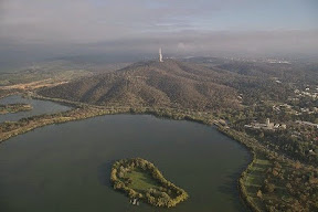
The homestead of the property was on the high ground that now forms Springbank Island in modern day Lake Burley Griffin. Springbank Island (if you can get to it) is an island within Lake Burley Griffin named after the 'Springbank Property'. The Island has a jetty at its southern end and barbecue and toilet facilities, shelter, and a few lights at its northern end. The perimeter of the Island is lined with trees. The Island is quite bare. There is a two-burner electric barbecue situated on the western side of the Island. There is access to fresh water on the Island. Camping on the Island is not permitted.


